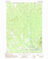
1986 Map of Island Falls
USGS Topo · Published 1986About this map
The West Branch Mattawamkeag River defines the central topography of this Aroostook County survey, winding past Warren Falls and Stair Falls before reaching the village of Island Falls. The landscape reflects a mid-1980s transition where traditional river-based industry meets modern infrastructure, evidenced by the Bangor and Aroostook railroad line and a local Waste Treatment facility. Smaller settlements such as Belvedere and Batesville occupy the western and northern fringes, while the eastern portion is dominated by the steep ascent of Robinson Mtn and De Lette Ridge. This map records a time of continued reliance on the local waterways, with Fish Stream and Alder Brook feeding into the Mattawamkeag, and various Gravel Pits indicating the active extraction of resources from the glacial terrain.
Find a feature on this map
26 named features on this map. Tap any name to fly to it.
Don’t see what you’re looking for? This feature index may not catch every label — zoom into the map to look around manually.
Map Details
Editions of this 1986 Island Falls Map
This is the sole edition of this map. No revisions or reprints were ever made.
Other maps of this area

1937 · Smyrna Mills
USGS Topo · 1:62,500

1940 · Island Falls
USGS Topo · 1:62,500

1940 · Sherman
USGS Topo · 1:62,500

1941 · Mattawamkeag Lake
USGS Topo · 1:62,500

1942 · Island Falls
USGS Topo · 1:62,500

1942 · Sherman
USGS Topo · 1:62,500

1943 · Mattawamkeag Lake
USGS Topo · 1:62,500

1954 · Presque Isle
USGS Topo · 1:250,000

1954 · Millinocket
USGS Topo · 1:250,000

1955 · Smyrna Mills
USGS Topo · 1:62,500