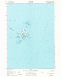
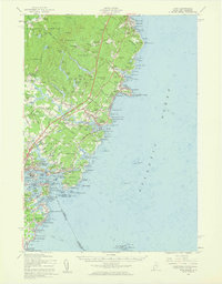
1956 Map of Isles Of Shoals
USGS Topo · Published 1974About this map
The rocky archipelago of the Isles of Shoals straddles the maritime border of Kittery, Maine, and Rye, New Hampshire. This survey, compiled from mid-century planetable work and updated with 1970s aerial photography, details the rugged outcroppings of the Atlantic Ocean before modern developments altered the coastlines. Concentrated human activity is centered on the larger islands, where a small Cem and Lighthouse mark the enduring presence of fishing and seafaring communities. The complex geography of Gosport Harbor is shielded by Smuttynose Island and Star Island, revealing a coastline defined by dangerous submerged hazards like Anderson Ledge and White Island Ledge. The map captures the remote character of these islands, including the smaller, less-frequented Duck Island and Lunging Island, illustrating a landscape of specialized survival and maritime navigation.
Find a feature on this map
29 named features on this map. Tap any name to fly to it.
Don’t see what you’re looking for? This feature index may not catch every label — zoom into the map to look around manually.
Map Details
Editions of this 1956 Isles Of Shoals Map
2 editions found
Other maps of this area

1893 · York
USGS Topo · 1:62,500

1920 · York
USGS Topo · 1:62,500

1943 · Cape Ann
USGS Topo · 1:125,000
1944 · Kittery
USGS Topo · 1:24,000

1948 · Boston
USGS Topo · 1:250,000

1949 · Portland
USGS Topo · 1:250,000
1956 · Kittery
USGS Topo · 1:24,000
1956 · Isles Of Shoals
USGS Topo · 1:24,000
1956 · York
USGS Topo · 1:62,500

1956 · Portland
USGS Topo · 1:250,000