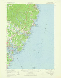
1956 Map of York
USGS Topo · Published 1960About this map
Coastal Maine and New Hampshire meet at the mouth of the Piscataqua River, where the Portsmouth Naval Shipyard and several defensive installations, including Fort Constitution and Fort Stark, dominate the harbor entrance. This mid-century survey reveals a landscape of established maritime villages like York Harbor and Kittery Point alongside the rising influence of tourism and infrastructure. The Maine Turnpike and U S Highway 1 cut through the interior, bypassing older crossroads like Scotland and Agamenticus Village. Along the rocky shoreline, landmarks like the Cape Neddick Lighthouse and the high elevations of Mt Agamenticus served as vital navigational aids. The map also captures the distinct character of summer colonies at York Beach and Ogunquit, contrasting the developing shore with the wooded, swamp-filled interior of York Woods.
Find a feature on this map
156 named features on this map. Tap any name to fly to it.
Don’t see what you’re looking for? This feature index may not catch every label — zoom into the map to look around manually.
Map Details
Editions of this 1956 York Map
4 editions found
Other maps of this area

1888 · Newburyport
USGS Topo · 1:62,500

1890 · Newburyport
USGS Topo · 1:62,500

1891 · Biddeford
USGS Topo · 1:62,500

1891 · Berwick
USGS Topo · 1:62,500

1891 · Kennebunk
USGS Topo · 1:62,500

1893 · Kennebunk
USGS Topo · 1:62,500

1893 · Dover
USGS Topo · 1:62,500

1893 · Berwick
USGS Topo · 1:62,500

1893 · York
USGS Topo · 1:62,500

1893 · Biddeford
USGS Topo · 1:62,500