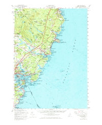
1956 Map of York
USGS Topo · Published 1973About this map
The rocky coastline and maritime culture of southern Maine are documented in this 1956 survey, centered on the historic communities of York Village and Kittery. The landscape is dominated by the prominence of Mt Agamenticus and a network of coastal features including the Cape Neddick Nubble Lighthouse and the intricate waters of Brave Boat Harbor. Military and naval history is prominently featured at the southern edge, with the Portsmouth Naval Base and several coastal defense sites like U S Naval Res (Fort Foster) and U S Mil Res (Fort Dearborn).
Find a feature on this map
168 named features on this map. Tap any name to fly to it.
Don’t see what you’re looking for? This feature index may not catch every label — zoom into the map to look around manually.
Map Details
Editions of this 1956 York Map
4 editions found
Other maps of this area

1888 · Newburyport
USGS Topo · 1:62,500

1890 · Newburyport
USGS Topo · 1:62,500

1891 · Biddeford
USGS Topo · 1:62,500

1891 · Berwick
USGS Topo · 1:62,500

1891 · Kennebunk
USGS Topo · 1:62,500

1893 · Kennebunk
USGS Topo · 1:62,500

1893 · Dover
USGS Topo · 1:62,500

1893 · Berwick
USGS Topo · 1:62,500

1893 · York
USGS Topo · 1:62,500

1893 · Biddeford
USGS Topo · 1:62,500