1944 Map of Kittery
USGS Topo · Published 1944About this map
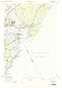
The coastal fortifications of the Piscataqua River dominate this wartime survey, showing a landscape heavily mobilized for defense. Portsmouth Harbor is anchored by a network of historic and active military sites, including Fort Constitution and Fort Stark on New Castle Island, and Fort Dearborn further south along the shore. The civilian and military overlap is evident in housing developments like Admiralty Village and the proximity of the Wentworth Hotel to Little Harbor. Inland, the area retains its rural character with family-named landmarks such as Highland Cem, Shapleigh Sch, and numerous crossings along the Boston and Maine RR like Paynes Crossing. This period represents the peak of coastal defense before the post-war transition, preserving the exact footprint of Camp Langdon and various military reservations.
Find a feature on this map
103 named features on this map. Tap any name to fly to it.
Don’t see what you’re looking for? This feature index may not catch every label — zoom into the map to look around manually.
Map Details
Editions of this 1944 Kittery Map
2 editions found

Other maps of this area

1888 · Newburyport
USGS Topo · 1:62,500

1890 · Newburyport
USGS Topo · 1:62,500

1893 · Dover
USGS Topo · 1:62,500

1893 · York
USGS Topo · 1:62,500

1894 · Newburyport
USGS Topo · 1:62,500

1916 · Dover
USGS Topo · 1:62,500

1918 · Dover
USGS Topo · 1:62,500

1920 · York
USGS Topo · 1:62,500

1932 · Newburyport
USGS Topo · 1:48,000

1934 · Exeter
USGS Topo · 1:62,500