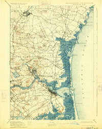
1932 Map of Newburyport
USGS Topo · Published 1932About this map
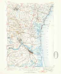
Exeter serves as a prominent educational and rail hub in the early 1930s, anchored by the campus of Phillips Exeter Academy and the Boston and Maine RR corridor. The landscape is characterized by a high density of named family corners and small district schools, such as The Plains Sch and Boyd Sch, which reflect a well-established rural settlement pattern before the expansion of modern highway systems. The coastal stretch from Plaice Cove down to Seabrook Beach shows early 20th-century resort development, particularly at The Willows and the prominent Great Boars Head. Inland, the terrain is defined by numerous named hills like Bride Hill and Moulton Ridge, while the drainage of the Taylor River and Hampton River systems shapes the marshes and farming valleys of Hampton Falls and Seabrook.
Find a feature on this map
95 named features on this map. Tap any name to fly to it.
Don’t see what you’re looking for? This feature index may not catch every label — zoom into the map to look around manually.
Map Details
Editions of this 1932 Newburyport Map
4 editions found

Historical Maps of Haverhill Through Time
5 maps found