
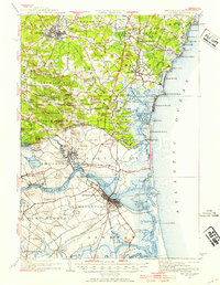
1932 Map of Exeter
USGS Topo · Published 1958About this map
The Exeter River and Merrimack River define the commercial and residential hubs of this coastal borderland during the early 1930s. Centered on the prestigious Phillips Exeter Academy, the town of Exeter serves as a primary inland node, while the Boston and Maine Railroad connects established maritime centers like Newburyport and Salisbury. The landscape is a mosaic of family-named heights and corners, such as Tappan Corners and Nason Corners, reflecting a deeply rooted settlement pattern before the modern highway era. Along the Atlantic shore, seasonal and maritime activity is evident at Hampton Beach and the U.S. Life Saving Station, while industrial and transit links are visible at the Hampton Falls Sta and the Salisbury Branch. The map captures the region's character as a network of mill towns and farming hamlets transitioning toward a modern coastal economy.
Find a feature on this map
150 named features on this map. Tap any name to fly to it.
Don’t see what you’re looking for? This feature index may not catch every label — zoom into the map to look around manually.
Map Details
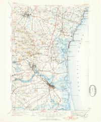
Editions of this 1932 Exeter Map
4 editions found

Other maps of this area

1886 · Gloucester
USGS Topo · 1:62,500

1886 · Lawrence
USGS Topo · 1:62,500

1888 · Newburyport
USGS Topo · 1:62,500

1888 · Haverhill
USGS Topo · 1:62,500

1888 · Gloucester
USGS Topo · 1:62,500

1888 · Lawrence
USGS Topo · 1:62,500

1888 · Salem
USGS Topo · 1:62,500

1890 · Haverhill
USGS Topo · 1:62,500

1890 · Newburyport
USGS Topo · 1:62,500

1893 · Dover
USGS Topo · 1:62,500