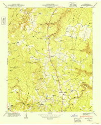
1949 Map of Isoline
USGS Topo · Published 1949About this map
The Alvin York Highway serves as the central artery through this portion of the Cumberland Plateau, tracing a north-south path through a landscape defined by deeply incised drainage systems like How Come You Creek and Drowning Creek. Small communities and family hubs are scattered throughout the territory, from the rail-adjacent Creston near the Tennessee Central line to the named settlement at Isoline. Local genealogy is well-preserved through numerous small burial grounds such as Terrell Cem, Tate Cem, and Dixon Cem. The presence of several schools, including Tabor Sch and Bowman Sch, alongside landmarks like the Lookout Tower atop Big Hill, suggests a well-distributed rural population in the late 1940s. The southeastern corner of the map reveals the winding course of the Obed River, featuring the distinctive Gould Bend and Parker Ford.
Find a feature on this map
95 named features on this map. Tap any name to fly to it.
Don’t see what you’re looking for? This feature index may not catch every label — zoom into the map to look around manually.
Map Details
Editions of this 1949 Isoline Map
This is the sole edition of this map. No revisions or reprints were ever made.
Other maps of this area

1887 · Kingston
USGS Topo · 1:125,000

1891 · Kingston
USGS Topo · 1:125,000

1892 · Pikeville
USGS Topo · 1:125,000

1893 · Kingston
USGS Topo · 1:125,000

1895 · Wartburg
USGS Topo · 1:125,000

1895 · Pikeville
USGS Topo · 1:125,000

1896 · Wartburg
USGS Topo · 1:125,000

1897 · Standingstone
USGS Topo · 1:125,000

1898 · Standingstone
USGS Topo · 1:125,000

1912 · Crossville
USGS Topo · 1:62,500