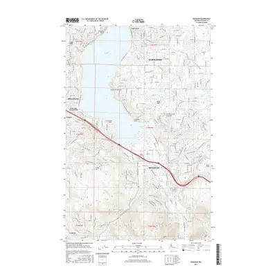
2017 Map of Issaquah
USGS Topo · Published 2017About this map
Lake Sammamish anchors this landscape, surrounded by the rapidly developed residential corridors of Bellevue, Sammamish, and Issaquah. The topography transitions sharply from the shoreline points like Greenwood Point and Alexander Beach to the significant elevations of Cougar Mtn, Squak Mtn, and Tiger Mtn in the south. This modern survey illustrates the dense suburban grid and major transportation artery of I-90 as it skirts the southern tip of the lake near Jensens Cove. Local community life is marked by landmarks such as the Sammamish Christian Sch and Noah's Ark Preschool and Hillside Cem. Smaller water bodies like Phantom Lake and Pine Lake sit atop the plateaus, reflecting the post-war suburban transformation of former timber and mining lands near Coalfield.
Find a feature on this map
45 named features on this map. Tap any name to fly to it.
Don’t see what you’re looking for? This feature index may not catch every label — zoom into the map to look around manually.
Map Details
Editions of this 2017 Issaquah Map
This is the sole edition of this map. No revisions or reprints were ever made.
Other maps of this area

1895 · Snohomish
USGS Topo · 1:125,000

1897 · Tacoma
USGS Topo · 1:125,000

1897 · Seattle
USGS Topo · 1:125,000

1900 · Tacoma
USGS Topo · 1:125,000

1913 · Cedar Lake
USGS Topo · 1:125,000

1921 · Sultan
USGS Topo · 1:125,000

1923 · Sultan
USGS Topo · 1:125,000

1949 · Maple Valley
USGS Topo · 1:24,000

1949 · Renton
USGS Topo · 1:24,000

1950 · Redmond
USGS Topo · 1:24,000