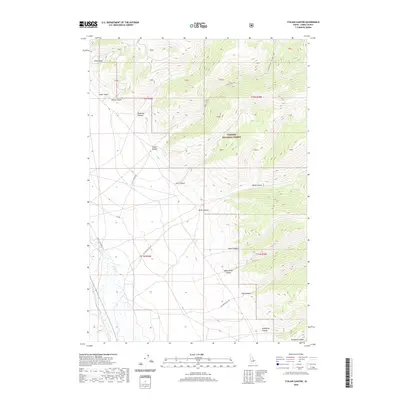
2020 Map of Italian Canyon
USGS Topo · Published 2020About this map
Targhee National Forest dominates the high-elevation eastern half of this Lemhi County landscape, where deep canyons and gulches carve their way through the mountain front toward the western flats. A complex drainage system including Crooked Creek - Willow Creek and Birch Cr defines the water movement through these steep slopes. The terrain is marked by numerous family-named or landmark-inspired features like Viola Gulch, Wilmot Gulch, and Eidelman Canyon, suggesting the early ranching and prospecting history of this part of Idaho. Access into this high country is facilitated by a network of backroads, including Scott Canyon Rd and various Forest Service routes like Nat For Dev Rd 190, which connect the lowland valleys to the more vertical stretches of Italian Canyon and Indian Head Canyon.
Find a feature on this map
33 named features on this map. Tap any name to fly to it.
Don’t see what you’re looking for? This feature index may not catch every label — zoom into the map to look around manually.
Map Details
Editions of this 2020 Italian Canyon Map
This is the sole edition of this map. No revisions or reprints were ever made.
Other maps of this area

1955 · Dubois
USGS Topo · 1:250,000

1956 · Nicholia
USGS Topo · 1:62,500

1957 · Diamond Peak
USGS Topo · 1:62,500

1957 · Scott Peak
USGS Topo · 1:62,500

1958 · Dubois
USGS Topo · 1:250,000

1969 · Copper Mtn
USGS Topo · 1:24,000
1969 · Blue Dome
USGS Topo · 1:24,000

1983 · Dubois
USGS Topo · 1:100,000
1987 · Eighteenmile Peak
USGS Topo · 1:24,000
1987 · Deadman Lake
USGS Topo · 1:24,000