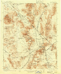
1912 Map of Ivanpah
USGS Topo · Published 1941About this map
Mining operations and early twentieth-century rail lines define this desert landscape crossing the California and Nevada border. The San Pedro Los Angeles and Salt Lake RR serves as a central artery through the Ivanpah Valley, connecting settlements like Jean, Nipton, and Kelso. To the east, the Atchison Topeka and Santa Fe RR branches toward mining centers such as Vanderbilt and Barnwell. Significant industrial activity is evident in the Spring Mountain Range and McCullough Range, where deep-earth works like the Keystone Mine, Yellow Pine Mine, and the Potosi Mine were established. The presence of an Abandoned Well and a Copper Smelter (Abandoned) near Valley Wells suggests the shifting fortunes of the region's extraction economy. For travelers and stock, critical water stops are identified at Marl Spr, Stump Spr, and Cottonwood Spring.
Find a feature on this map
124 named features on this map. Tap any name to fly to it.
Don’t see what you’re looking for? This feature index may not catch every label — zoom into the map to look around manually.
Map Details
Editions of this 1912 Ivanpah Map
5 editions found
Other maps of this area

1886 · Camp Mohave
USGS Topo · 1:250,000

1886 · Saint Thomas
USGS Topo · 1:250,000

1892 · Camp Mohave
USGS Topo · 1:250,000

1893 · Saint Thomas
USGS Topo · 1:250,000

1907 · Las Vegas
USGS Topo · 1:250,000

1908 · Furnace Creek
USGS Topo · 1:250,000

1908 · Las Vegas
USGS Topo · 1:250,000

1910 · Furnace Creek
USGS Topo · 1:250,000

1910 · Ivanpah
USGS Topo · 1:250,000

1912 · Ivanpah
USGS Topo · 1:250,000