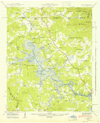
1942 Map of Ivylog
USGS Topo · Published 1942About this map
The Nottely Reservoir dominates this 1941 field examination, its waters backing up behind the Nottely Dam to flood the winding bends of the Nottely River. This Tennessee Valley Authority project fundamentally altered the landscape of Union County, drowning old river bottoms while leaving high points like Davenport Mountain as prominent features of the new shoreline. The map documents the rural infrastructure of the early 1940s, including small community hubs such as Bellview and Ivylog, and numerous rural schools and churches like Macedonia Sch and New Hope Ch. Industrial remnants of the pre-reservoir era are visible through labels for Cook Mill and Tate Mill, while the high ridges of the Chattahoochee National Forest and Nantahala National Forest provide a stable backdrop to the transforming valley below.
Find a feature on this map
89 named features on this map. Tap any name to fly to it.
Don’t see what you’re looking for? This feature index may not catch every label — zoom into the map to look around manually.
Map Details
Editions of this 1942 Ivylog Map
This is the sole edition of this map. No revisions or reprints were ever made.
Other maps of this area

1886 · Dahlonega
USGS Topo · 1:125,000

1888 · Ellijay
USGS Topo · 1:125,000

1892 · Dahlonega
USGS Topo · 1:125,000

1892 · Ellijay
USGS Topo · 1:125,000

1893 · Murphy
USGS Topo · 1:125,000

1896 · Dahlonega
USGS Topo · 1:125,000

1898 · Ellijay
USGS Topo · 1:125,000

1903 · Dahlonega
USGS Topo · 1:125,000

1911 · Ellijay
USGS Topo · 1:125,000

1914 · Murphy
USGS Topo · 1:125,000