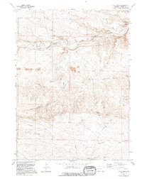
1991 Map of J H D Ranch
USGS Topo · Published 1995About this map
Horse Creek and Trail Creek wind through this Laramie County ranchland, defining a landscape dominated by specialized cattle operations and water management. The ranching infrastructure is exceptionally dense, featuring a network of seasonal and functional outposts such as Upper JHD Camp, Tomato Camp, and Kruger Camp. These sites, along with the J H D Supply Ditch, illustrate the intensive management of high-plains grazing land in the late 20th century. The presence of named camps like Lucy Huey Camp and School Section Camp suggests a history of decentralized stewardship across the J H D Ranch holdings. In the southern portion, Chivington Draw cuts through the terrain, while the J H D Trail and J H D Road provide the primary transit corridors for this working landscape.
Find a feature on this map
26 named features on this map. Tap any name to fly to it.
Don’t see what you’re looking for? This feature index may not catch every label — zoom into the map to look around manually.
Map Details
Editions of this 1991 J H D Ranch Map
This is the sole edition of this map. No revisions or reprints were ever made.
Other maps of this area

1911 · Cheyenne
USGS Topo · 1:125,000

1914 · Cheyenne
USGS Topo · 1:125,000

1954 · Cheyenne
USGS Topo · 1:250,000

1958 · Cheyenne
USGS Topo · 1:250,000

1962 · P O Ranch
USGS Topo · 1:24,000

1962 · Moffett Ranch
USGS Topo · 1:24,000

1962 · Lewis Ranch
USGS Topo · 1:24,000

1963 · Little Indian Draw
USGS Topo · 1:24,000

1963 · Pole Creek Ranch SE
USGS Topo · 1:24,000
1963 · Pole Creek Ranch
USGS Topo · 1:24,000