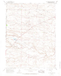
1963 Map of Pole Creek Ranch
USGS Topo · Published 1967About this map
Pole Creek Ranch and several dispersed ranching outposts define this high plains landscape in Laramie County during the early 1960s. The drainage of Lodgepole Creek serves as the primary corridor for settlement and water management, evidenced by the Pole Creek Reservoir and numerous named camps such as Berry Camp, Rabbit Camp, and Eagle Camp. These camps, along with Peegh Camp and Middle Camp, reflect a specialized agricultural or livestock management system partitioned by a network of fence lines and dirt tracks like J H D Road. The terrain is deeply incised by seasonal waterways including Antelope Draw and Ninemile Draw, while local industry is represented by a Gravel Pit and a mapped Drill Hole near the southern edge of the survey.
Find a feature on this map
17 named features on this map. Tap any name to fly to it.
Don’t see what you’re looking for? This feature index may not catch every label — zoom into the map to look around manually.
Map Details
Editions of this 1963 Pole Creek Ranch Map
2 editions found
Other maps of this area

1911 · Cheyenne
USGS Topo · 1:125,000

1914 · Cheyenne
USGS Topo · 1:125,000

1950 · Cheyenne
USGS Topo · 1:62,500

1954 · Cheyenne
USGS Topo · 1:250,000

1958 · Cheyenne
USGS Topo · 1:250,000

1961 · Cheyenne
USGS Topo · 1:62,500

1961 · Cheyenne North
USGS Topo · 1:24,000

1962 · P O Ranch
USGS Topo · 1:24,000

1962 · Lewis Ranch
USGS Topo · 1:24,000

1963 · Little Indian Draw
USGS Topo · 1:24,000