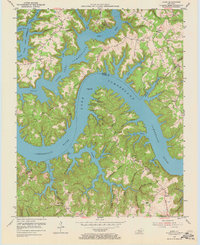
1954 Map of Jabez
USGS Topo · Published 1973About this map
Lake Cumberland dominates the landscape in this mid-century survey, its fingers reaching deep into the dissected uplands of Russell and Wayne counties. The map captures the shoreline of the reservoir, including Camp Earl Wallace and various named points like Polston Ridge and Ono Ridge. Small settlements and family clusters are scattered across the high ground between the water, including Jabez, Ono, and Eadsville. Cultural landmarks are prominently featured, such as Mount Pleasant Ch, the Military Cem, and several local educational sites including Flanagan Sch and Piney Woods Sch. The intricate network of hollows, such as Turkey Pen Hollow and Rock Bridge Hollow, reveals the complex topography of the Cumberland River basin during a period of transition as the lake's waters reshaped the local geography.
Find a feature on this map
60 named features on this map. Tap any name to fly to it.
Don’t see what you’re looking for? This feature index may not catch every label — zoom into the map to look around manually.
Map Details
Editions of this 1954 Jabez Map
2 editions found
Other maps of this area

1911 · Monticello
USGS Topo · 1:62,500

1914 · Monticello
USGS Topo · 1:62,500

1953 · Parnell
USGS Topo · 1:24,000

1953 · Monticello
USGS Topo · 1:24,000

1953 · Mill Springs
USGS Topo · 1:24,000

1953 · Jamestown
USGS Topo · 1:24,000

1954 · Jabez
USGS Topo · 1:24,000

1954 · Cumberland City
USGS Topo · 1:24,000

1954 · Russell Springs
USGS Topo · 1:24,000

1954 · Eli
USGS Topo · 1:24,000