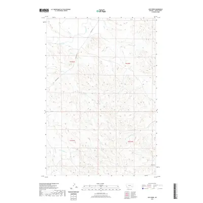
2020 Map of Jack Creek
USGS Topo · Published 2020About this map
The Tongue River meanders through the northwestern corner of this Montana landscape, tracing a path that has historically dictated the movement of travel and water in Custer County. Following the river's western bank, the Tongue River Rd provides the primary corridor through this section of the Tongue River Valley, where the terrain is defined by a dense network of coulees and seasonal drainages. Numerous watercourses like Plunket Cr, Jack Cr, and Ash Cr dissect the high ground, creating a complex series of ridges and draws. In the southeast, Red Butte stands as a prominent landmark above the surrounding basins of Winter Cr and Butte Cr. This 2020 survey documents the enduring pastoral character of the region, where land use remains closely tied to the natural hydrology and the historical township boundaries of T3N and T4N.
Find a feature on this map
18 named features on this map. Tap any name to fly to it.
Don’t see what you’re looking for? This feature index may not catch every label — zoom into the map to look around manually.
Map Details
Editions of this 2020 Jack Creek Map
This is the sole edition of this map. No revisions or reprints were ever made.
Other maps of this area

1953 · Miles City
USGS Topo · 1:250,000

1954 · Ekalaka
USGS Topo · 1:250,000

1956 · Ekalaka
USGS Topo · 1:250,000

1957 · Miles City
USGS Topo · 1:250,000

1958 · Miles City
USGS Topo · 1:250,000

1958 · Ekalaka
USGS Topo · 1:250,000

1965 · Ekalaka
USGS Topo · 1:250,000
1969 · Jack Creek NW
USGS Topo · 1:24,000

1969 · Horse Creek
USGS Topo · 1:24,000

1969 · Circle L Creek
USGS Topo · 1:24,000