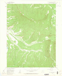
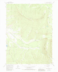
1956 Map of Jack Creek Ranch
USGS Topo · Published 1963About this map
Routt National Forest dominates this mid-century topographic study, defined by the high-elevation terrain of Owl Mountain and the headwaters of the Illinois River. The landscape reveals a complex network of early irrigation efforts, including the Garland Ditch, Flying Dutchman Ditch, and Jack Ditch, which redirect water across the drainage divides. These man-made features highlight the era's reliance on water rights to support remote homesteads like Roslyn Ranch and the Jack Creek Ranch.
Find a feature on this map
48 named features on this map. Tap any name to fly to it.
Don’t see what you’re looking for? This feature index may not catch every label — zoom into the map to look around manually.
Map Details
Editions of this 1956 Jack Creek Ranch Map
6 editions found
Other maps of this area

1915 · Longs Peak
USGS Topo · 1:125,000

1916 · Home
USGS Topo · 1:125,000

1919 · Rocky Mountain National Park
USGS Topo · 1:125,000

1920 · Home
USGS Topo · 1:125,000

1954 · Greeley
USGS Topo · 1:250,000

1954 · Craig
USGS Topo · 1:250,000

1955 · Gould
USGS Topo · 1:24,000

1955 · Owl Ridge
USGS Topo · 1:24,000

1956 · Radial Mountain
USGS Topo · 1:24,000

1956 · Jack Creek Ranch
USGS Topo · 1:24,000