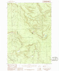
1986 Map of Jack Straw Basin
USGS Topo · Published 1986About this map
Yellowstone National Park and the Gallatin National Forest meet in this high-altitude wilderness along the Montana-Wyoming border. This 1986 survey illustrates a landscape defined by deep drainages and high plateaus, where the continental divide influences the flow of seasonal waters. The topography is shaped by prominent features like Jack Straw Basin and the expansive Moose Creek Plateau, which transitions into a series of steep canyons.
Find a feature on this map
16 named features on this map. Tap any name to fly to it.
Don’t see what you’re looking for? This feature index may not catch every label — zoom into the map to look around manually.
Map Details
Editions of this 1986 Jack Straw Basin Map
This is the sole edition of this map. No revisions or reprints were ever made.
Other maps of this area

1885 · Gallatin
USGS Topo · 1:125,000

1885 · Gallatin
USGS Topo · 1:125,000

1886 · Shoshone
USGS Topo · 1:125,000

1888 · Shoshone
USGS Topo · 1:125,000

1895 · Shoshone
USGS Topo · 1:125,000

1901 · Shoshone
USGS Topo · 1:125,000

1901 · Gallatin
USGS Topo · 1:125,000

1908 · Gallatin
USGS Topo · 1:125,000

1908 · Shoshone
USGS Topo · 1:125,000

1911 · Shoshone
USGS Topo · 1:125,000