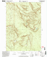
2000 Map of Jack Straw Basin
USGS Topo · Published 2005About this map
Yellowstone National Park and Gallatin National Forest meet in this high-altitude borderland, where the state line between Montana and Wyoming follows a complex physical and political geography. The landscape is defined by its deep drainages and expansive heights, including the Moose Creek Plateau and the prominent Jack Straw Basin. A notable human outpost is the South Riverside Cabin, situated near a spring along the winding path of Echo Canyon. This survey captures the intricate boundary system where Gallatin County and Teton County converge, showing the network of canyons such as Meadow Canyon and Black Bear Canyon that carve through the high country. Small alpine water features like Big Bear Lake and Frog Pond punctuate the high-elevation terrain near Rocky Draw, illustrating the hydrological patterns of the headwaters region before modern development.
Find a feature on this map
18 named features on this map. Tap any name to fly to it.
Don’t see what you’re looking for? This feature index may not catch every label — zoom into the map to look around manually.
Map Details
Editions of this 2000 Jack Straw Basin Map
This is the sole edition of this map. No revisions or reprints were ever made.
Other maps of this area

1885 · Gallatin
USGS Topo · 1:125,000

1885 · Gallatin
USGS Topo · 1:125,000

1886 · Shoshone
USGS Topo · 1:125,000

1888 · Shoshone
USGS Topo · 1:125,000

1895 · Shoshone
USGS Topo · 1:125,000

1901 · Shoshone
USGS Topo · 1:125,000

1901 · Gallatin
USGS Topo · 1:125,000

1908 · Gallatin
USGS Topo · 1:125,000

1908 · Shoshone
USGS Topo · 1:125,000

1911 · Shoshone
USGS Topo · 1:125,000