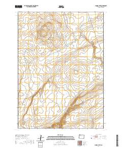
2020 Map of Jackies Butte
USGS Topo · Published 2020About this map
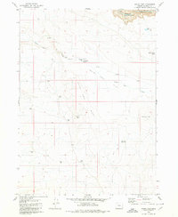
Jackies Butte and the volcanic depression of Bowden Crater dominate this high-desert landscape in southeastern Oregon. The terrain is defined by its water management features, critical for ranching in this arid environment. Strategic water points such as Bull Canyon Reservoir, Squaw Flat Reservoir, and Long Water Holes are scattered across the quadrangle, illustrating the complex hydrology of a region where ephemeral drainages like Bull Cr and Dry Cr only flow seasonally. To the south, Beber Ranch Rd provides limited access near the meandering courses of Chimney Cr and Rattlesnake Cr. This 2020 survey highlights a remote section of Malheur County where the natural volcanic geology of landmarks like Water Hole Butte dictates the placement of essential water infrastructure and primitive road networks.
Find a feature on this map
15 named features on this map. Tap any name to fly to it.
Don’t see what you’re looking for? This feature index may not catch every label — zoom into the map to look around manually.
Map Details
Editions of this 2020 Jackies Butte Map
This is the sole edition of this map. No revisions or reprints were ever made.
Other maps of this area

1955 · Jordan Valley
USGS Topo · 1:250,000

1957 · Jordan Valley
USGS Topo · 1:250,000

1958 · Jordan Valley
USGS Topo · 1:250,000

1979 · Rockhouse Reservoir
USGS Topo · 1:24,000

1979 · Bowden Ranch
USGS Topo · 1:24,000
1979 · The Basin
USGS Topo · 1:24,000
1980 · Caviatta Ridge
USGS Topo · 1:24,000
1980 · Jackies Butte
USGS Topo · 1:24,000
1980 · Indian Fort
USGS Topo · 1:24,000

1982 · Rattlesnake Canyon
USGS Topo · 1:24,000