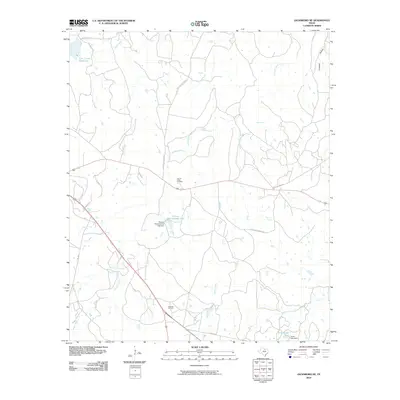
2010 Map of Jacksboro NE
USGS Topo · Published 2010About this map
Carroll Creek Cemetery and the industrial activity of the Rusmag Oil Field define this rural landscape northeast of Jacksboro. The terrain is characterized by a network of drainage systems including Carroll Creek, Snake Creek, and Beans Creek, which feed into various man-made water features. Managed hydrology is a significant theme of the area, evidenced by the presence of Thomas Cherryhomes Lake and Annin Lake, both shown with their respective dams. The northwestern corner of the quadrangle is dominated by the Lost Creek Reservoir, a primary water resource for the region. A series of ranch and county roads, such as Coca Cola Ranch Rd and Dos Equis Ranch Rd, provide access through the rolling topography and the distinctive low-lying Crooked Hollow.
Find a feature on this map
21 named features on this map. Tap any name to fly to it.
Don’t see what you’re looking for? This feature index may not catch every label — zoom into the map to look around manually.
Map Details
Editions of this 2010 Jacksboro NE Map
This is the sole edition of this map. No revisions or reprints were ever made.
Other maps of this area

1954 · Sherman
USGS Topo · 1:250,000

1954 · Wichita Falls
USGS Topo · 1:250,000

1958 · Wichita Falls
USGS Topo · 1:250,000

1958 · Sherman
USGS Topo · 1:250,000

1960 · Gibtown
USGS Topo · 1:24,000

1960 · Wizard Wells
USGS Topo · 1:24,000

1960 · Jacksboro
USGS Topo · 1:24,000
1961 · Bartons Chapel
USGS Topo · 1:24,000
1961 · Perrin
USGS Topo · 1:24,000

1961 · Jacksboro NE
USGS Topo · 1:24,000