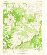
1961 Map of Bartons Chapel
USGS Topo · Published 1962About this map
The rural community of Bartons Chapel anchors this 1961 survey, situated within the rolling ranch lands of Jack County. This era reveals a landscape transitioning between traditional agriculture and the growing energy sector, with numerous Oil Wells and a network of Pipeline corridors cutting across the terrain. Local genealogy is well-preserved through markers like the Bartons Chapel Cem, Springdale Cem, and a standalone Cem near the county line, providing vital clues for researchers of north Texas families. The geography is defined by the headwaters of the Keechi Creek system, where the West Fork Keechi Creek and East Fork Keechi Creek drain the surrounding heights. High points such as Tettertiller Hill and VABM 1262 Barton overlook the Springdale Branch, illustrating the topographic relief that shaped early settlement patterns and road placements near the Jack Co Palo Pinto Co boundary.
Find a feature on this map
17 named features on this map. Tap any name to fly to it.
Don’t see what you’re looking for? This feature index may not catch every label — zoom into the map to look around manually.
Map Details
Editions of this 1961 Bartons Chapel Map
This is the sole edition of this map. No revisions or reprints were ever made.
Other maps of this area

1891 · Palo Pinto
USGS Topo · 1:125,000

1918 · Palo Pinto
USGS Topo · 1:125,000

1924 · Palo Pinto 2-a
USGS Topo · 1:48,000

1924 · Palo Pinto 1-b
USGS Topo · 1:48,000

1927 · Pickwick
USGS Topo · 1:62,500

1927 · Mineral Wells
USGS Topo · 1:62,500

1954 · Abilene
USGS Topo · 1:250,000

1954 · Wichita Falls
USGS Topo · 1:250,000

1958 · Wichita Falls
USGS Topo · 1:250,000

1958 · Abilene
USGS Topo · 1:250,000