
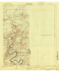
1927 Map of Mineral Wells
USGS Topo · Published 1927About this map
The Brazos River creates a dramatic series of oxbows through the center of this 1920s topography, winding past Ballenger Bend and Dog Bend toward Hittson Bend. This hydrology shaped the local movement and settlement patterns of the era, with Oakes Crossing providing a key river passage south of Mineral Wells. The industrial and transportation backbone of the region is defined by the Weatherford Mineral Wells and Northwestern railroad, which links the northern settlements of Graford and Oran.
Find a feature on this map
21 named features on this map. Tap any name to fly to it.
Don’t see what you’re looking for? This feature index may not catch every label — zoom into the map to look around manually.
Map Details
Editions of this 1927 Mineral Wells Map
2 editions found
Other maps of this area

1891 · Weatherford
USGS Topo · 1:125,000

1891 · Palo Pinto
USGS Topo · 1:125,000

1893 · Weatherford
USGS Topo · 1:125,000

1918 · Palo Pinto
USGS Topo · 1:125,000

1924 · Palo Pinto 2-a
USGS Topo · 1:48,000

1924 · Palo Pinto 1-b
USGS Topo · 1:48,000

1925 · Palo Pinto 4-b
USGS Topo · 1:48,000

1927 · Pickwick
USGS Topo · 1:62,500

1931 · Dennis
USGS Topo · 1:62,500

1931 · Santo
USGS Topo · 1:62,500