
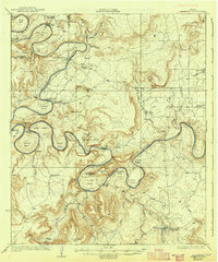
1927 Map of Pickwick
USGS Topo · Published 1927About this map
The Brazos River meanders in tight, dramatic loops across this 1920s landscape, creating a series of named bends like Fortune Bend and Costello Bend that define the local geography. Before the major dam projects transformed the basin, these oxbows were the heart of rural life, hosting the Fortune Bend School and several river fords such as Shut in Crossing. The topography is marked by significant elevations like McAdams Pk and School House Mtn, while the settlement of Pickwick and the nearby Mc Adams Cem provide critical touchpoints for family historians. This survey captures the region just before the creation of the massive reservoir, documenting the original Possum Kingdom terrain and the winding trails through McAdams Valley. On the eastern edge, the W. M. W. & N. W. railroad serves Graford, connecting the ranching country of Belding Ranch to wider markets.
Find a feature on this map
66 named features on this map. Tap any name to fly to it.
Don’t see what you’re looking for? This feature index may not catch every label — zoom into the map to look around manually.
Map Details
Editions of this 1927 Pickwick Map
2 editions found
Other maps of this area

1890 · Breckenridge
USGS Topo · 1:125,000

1891 · Palo Pinto
USGS Topo · 1:125,000

1918 · Palo Pinto
USGS Topo · 1:125,000

1924 · Breckenridge 1-a
USGS Topo · 1:48,000

1924 · Palo Pinto 2-b
USGS Topo · 1:48,000

1924 · Palo Pinto 2-a
USGS Topo · 1:48,000

1924 · Palo Pinto 1-b
USGS Topo · 1:48,000

1924 · Graham 4-d
USGS Topo · 1:48,000

1924 · Palo Pinto 2-c
USGS Topo · 1:48,000

1924 · Breckenridge 1-d
USGS Topo · 1:48,000