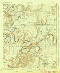
1927 Map of Pickwick
USGS Topo · Published 1942About this map
The Brazos River snakes through the heart of this landscape, creating a series of dramatic loops including Fortune Bend, Costello Bend, and Gaines Bend. This pre-reservoir era survey shows the river valley before the construction of major dams, where numerous crossings like Ioni Crossing and Garland Crossing provided essential transit for local ranchers. Significant family landmarks are scattered throughout, such as the Belding Ranch and the Mc Adams Cem near McAdams Pk.
Find a feature on this map
67 named features on this map. Tap any name to fly to it.
Don’t see what you’re looking for? This feature index may not catch every label — zoom into the map to look around manually.
Map Details
Editions of this 1927 Pickwick Map
2 editions found

Other maps of this area

1890 · Breckenridge
USGS Topo · 1:125,000

1891 · Palo Pinto
USGS Topo · 1:125,000

1918 · Palo Pinto
USGS Topo · 1:125,000

1924 · Breckenridge 1-a
USGS Topo · 1:48,000

1924 · Palo Pinto 2-b
USGS Topo · 1:48,000

1924 · Palo Pinto 2-a
USGS Topo · 1:48,000

1924 · Palo Pinto 1-b
USGS Topo · 1:48,000

1924 · Graham 4-d
USGS Topo · 1:48,000

1924 · Palo Pinto 2-c
USGS Topo · 1:48,000

1924 · Breckenridge 1-d
USGS Topo · 1:48,000