Loading...
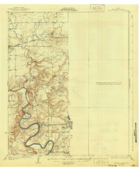
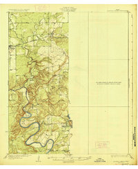
Loading map...1927 Map of Mineral Wells
USGS Topo · Published 1941About this map
The Brazos River winds through Palo Pinto County in dramatic loops, carving out named features such as Ballenger Bend and Hittson Bend. This landscape is defined by its watercourses, from the East Fork Keechi Creek to the smaller drainage of Devils Hollow. These natural barriers dictated the path of human infrastructure, most notably the Weatherford and Mineral Wells Northwestern railroad, which follows a relatively level corridor through the northern hills toward Oran.
Find a feature on this map
22 named features on this map. Tap any name to fly to it.
Don’t see what you’re looking for? This feature index may not catch every label — zoom into the map to look around manually.
Map Details
Date Portrayed1927
Date Published1941
PublisherU.S. Geological Survey
Map TypeTopographic
Scale1:62,500
Physical Dimensions17 x 20.8 inches
Editions of this 1927 Mineral Wells Map
2 editions found
Historical Maps of Mineral Wells Through Time
3 maps found
Featured Locations
Source Details
SourceU.S. Geological Survey
CopyrightPublic Domain