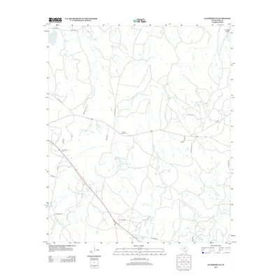
2012 Map of Jacksboro NE
USGS Topo · Published 2012About this map
Carroll Creek and its seasonal tributaries carve through this north-central Texas landscape in the early 21st century. The map reveals a rural economy shaped by ranching and energy extraction, centered on the Rusmag Oil Field near the southern boundary. Local history is anchored by the Carroll Creek Cem, situated near the intersection of several ranch-to-market and local roads. Private landholdings are marked by numerous small impoundments and significant water bodies like Thomas Cherryhomes Lake and the Lost Creek Reservoir in the northwest corner. A network of named ranch roads and trails, including Grizzly Ridge Rd, Dos Equis Ranch Rd, and Coca Cola Rch Rd, provides access across the terrain of Grizzly Rdg and down into Crooked Hollow.
Find a feature on this map
28 named features on this map. Tap any name to fly to it.
Don’t see what you’re looking for? This feature index may not catch every label — zoom into the map to look around manually.
Map Details
Editions of this 2012 Jacksboro NE Map
This is the sole edition of this map. No revisions or reprints were ever made.
Other maps of this area

1954 · Sherman
USGS Topo · 1:250,000

1954 · Wichita Falls
USGS Topo · 1:250,000

1958 · Wichita Falls
USGS Topo · 1:250,000

1958 · Sherman
USGS Topo · 1:250,000

1960 · Gibtown
USGS Topo · 1:24,000

1960 · Wizard Wells
USGS Topo · 1:24,000

1960 · Jacksboro
USGS Topo · 1:24,000
1961 · Bartons Chapel
USGS Topo · 1:24,000
1961 · Perrin
USGS Topo · 1:24,000

1961 · Jacksboro NE
USGS Topo · 1:24,000