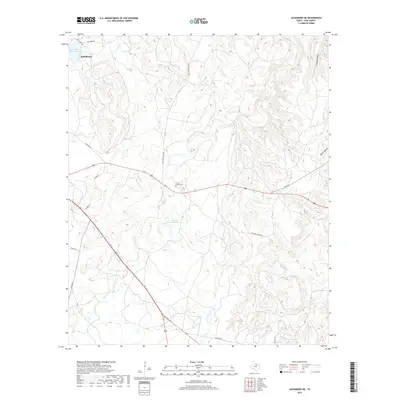
2019 Map of Jacksboro NE
USGS Topo · Published 2019About this map
The rugged ranchlands and drainages of northeast Jack County are defined by the winding paths of Lost Cr and Carroll Cr. While the edge of Jacksboro is visible in the northwest corner near the Lost Creek Reservoir, the landscape is largely characterized by sprawling private holdings and rural landmarks. Local history is anchored at the Carroll Creek Cem, situated near the intersection of several ranch roads. The terrain is deeply articulated by numerous small waterways and hollows, including Snake Cr and Beans Cr, which feed into private impoundments such as Thomas Cherryhomes Lake and Annin Lake. The network of roads, including Coca Cola Ranch Rd and Dos Equis Ranch Rd, reflects the prominence of large-scale ranching operations that have shaped this portion of North Texas.
Find a feature on this map
22 named features on this map. Tap any name to fly to it.
Don’t see what you’re looking for? This feature index may not catch every label — zoom into the map to look around manually.
Map Details
Editions of this 2019 Jacksboro NE Map
This is the sole edition of this map. No revisions or reprints were ever made.
Other maps of this area

1954 · Sherman
USGS Topo · 1:250,000

1954 · Wichita Falls
USGS Topo · 1:250,000

1958 · Wichita Falls
USGS Topo · 1:250,000

1958 · Sherman
USGS Topo · 1:250,000

1960 · Gibtown
USGS Topo · 1:24,000

1960 · Wizard Wells
USGS Topo · 1:24,000

1960 · Jacksboro
USGS Topo · 1:24,000
1961 · Bartons Chapel
USGS Topo · 1:24,000
1961 · Perrin
USGS Topo · 1:24,000

1961 · Jacksboro NE
USGS Topo · 1:24,000