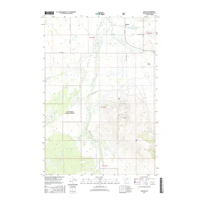
2017 Map of Jackson
USGS Topo · Published 2017About this map
Jackson stands at the heart of this high-altitude valley, where the headwaters of the Big Hole River create a complex network of wetlands and creeks. The landscape is defined by the transition from the broad, well-watered flats of Hamby Swamp and Little Swamp Cr to the rising timber of the Beaverhead National Forest. Geothermal activity is a focal point of the local geography, specifically at Jackson Hot Springs, while family-named landmarks like Patterson Springs and Spencer Springs suggest the long-standing ranching heritage of the Big Hole Valley. To the east, the terrain climbs toward Laphan Mtn and the local Ski Hill, overlooking the agricultural benchlands. This survey captures a rural landscape where infrastructure like Skinner Meadows Rd and Sitz Ranch Ln follows the natural contours of the river system, supporting the traditional cattle ranching economy of Beaverhead County.
Find a feature on this map
31 named features on this map. Tap any name to fly to it.
Don’t see what you’re looking for? This feature index may not catch every label — zoom into the map to look around manually.
Map Details
Editions of this 2017 Jackson Map
This is the sole edition of this map. No revisions or reprints were ever made.
Other maps of this area

1955 · Dillon
USGS Topo · 1:250,000

1956 · Goldstone Mtn
USGS Topo · 1:62,500

1957 · Dillon
USGS Topo · 1:250,000

1958 · Dillon
USGS Topo · 1:250,000

1962 · Dillon
USGS Topo · 1:250,000

1965 · Dillon
USGS Topo · 1:250,000

1966 · Miner Lake
USGS Topo · 1:24,000
1966 · Ajax Ranch
USGS Topo · 1:24,000
1978 · Jackson
USGS Topo · 1:24,000

1978 · Butch Hill
USGS Topo · 1:24,000