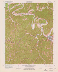
1961 Map of Jackson
USGS Topo · Published 1976About this map
North Fork Kentucky River defines the landscape of Breathitt County, winding through deep bends like Miller Bend and Cy Bend. The regional importance of Jackson is evident in its transport infrastructure, where the The Cutoff and O & K Tunnel pierce the terrain. The area's mid-century religious and educational character is grounded in sites like the Kentucky Mountain Bible Institute and Mt Carmel Sch, while industry is represented by numerous unnamed coal mines and gas wells scattered across the ridges. Small rural communities such as Lawson and Elkatawa serve as anchors for local genealogy, supported by family-named landmarks including Gabbard Flat Cem and Hagins Cem. The Louisville and Nashville railroad tracks follow the river's path, highlighting the vital link between rail transport and the mountain economy during this era.
Find a feature on this map
87 named features on this map. Tap any name to fly to it.
Don’t see what you’re looking for? This feature index may not catch every label — zoom into the map to look around manually.
Map Details
Editions of this 1961 Jackson Map
3 editions found
Other maps of this area

1889 · Salyersville
USGS Topo · 1:125,000

1891 · Manchester
USGS Topo · 1:125,000

1891 · Hazard
USGS Topo · 1:125,000

1891 · Salyersville
USGS Topo · 1:125,000

1892 · Beattyville
USGS Topo · 1:125,000

1899 · Salyersville
USGS Topo · 1:125,000

1913 · Buckhorn
USGS Topo · 1:62,500

1951 · Landsaw
USGS Topo · 1:24,000

1951 · Quicksand
USGS Topo · 1:24,000

1951 · Jackson
USGS Topo · 1:24,000