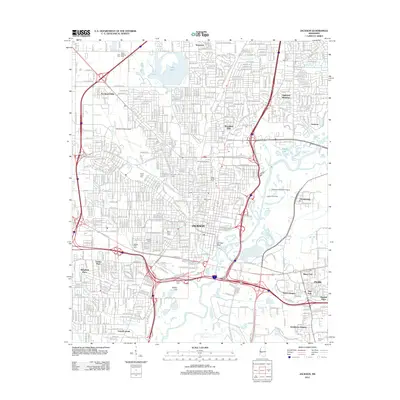
2012 Map of Jackson
USGS Topo · Published 2012About this map
Jackson, Mississippi, sits at a major crossroads of geography and infrastructure on this 2012 survey. The state capital's urban landscape is defined by the winding course of the Pearl River, which separates the main city from Flowood and Pearl to the east. Several historic burial grounds, including Greenwood Cem, Beth Israel Cem, and Mount Olive Cem, are situated within the city's established neighborhoods. The map illustrates a developed transportation network where I-55 and I-20 intersect, bordering the expansive green space of Le Fleur Bluff. Commercial and industrial activity is evidenced by the Jackson Gas Field and the presence of the Hawkins Field Airport and Flowood Industrial Airport. Water features like Lake Hico and Mayes Lake break the grid of residential communities such as Woodland Hills and Eastover, while Bailey Hill provides a distinct topographic landmark south of the city center.
Find a feature on this map
48 named features on this map. Tap any name to fly to it.
Don’t see what you’re looking for? This feature index may not catch every label — zoom into the map to look around manually.
Map Details
Editions of this 2012 Jackson Map
This is the sole edition of this map. No revisions or reprints were ever made.
Other maps of this area

1903 · Jackson
USGS Topo · 1:125,000

1905 · Jackson
USGS Topo · 1:48,000

1906 · Florence
USGS Topo · 1:62,500

1908 · Jackson
USGS Topo · 1:62,500

1908 · Florence
USGS Topo · 1:62,500

1934 · Raymond
USGS Topo · 1:48,000

1937 · Raymond
USGS Topo · 1:62,500

1937 · Terry
USGS Topo · 1:48,000

1942 · Raymond
USGS Topo · 1:62,500

1943 · Terry
USGS Topo · 1:62,500