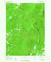
1945 Map of Jackson Summit
USGS Topo · Published 1963About this map
The Adirondack Park dominates this mid-1940s landscape, where the southern boundary of Hamilton County meets Fulton County. The rugged terrain is defined by a series of "vlys"—wetland depressions such as Moat Vly, Rocker Vly, and Round Vly—that indicate the region's complex post-glacial drainage patterns. Small, isolated settlements like Jackson Summit and Upper Benson are connected by a sparse road network, highlighting the area's rural character during the mid-twentieth century.
Find a feature on this map
40 named features on this map. Tap any name to fly to it.
Don’t see what you’re looking for? This feature index may not catch every label — zoom into the map to look around manually.
Map Details
Editions of this 1945 Jackson Summit Map
This is the sole edition of this map. No revisions or reprints were ever made.
Other maps of this area

1899 · Broadalbin
USGS Topo · 1:62,500

1902 · Broadalbin
USGS Topo · 1:62,500

1903 · Gloversville
USGS Topo · 1:62,500

1907 · Lake Pleasant
USGS Topo · 1:62,500

1910 · Stony Creek
USGS Topo · 1:62,500

1943 · Gloversville
USGS Topo · 1:62,500

1945 · Caroga Lake
USGS Topo · 1:24,000

1945 · Northville
USGS Topo · 1:24,000
1945 · Broadalbin
USGS Topo · 1:24,000
1945 · Gloversville
USGS Topo · 1:24,000