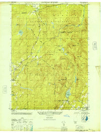
1946 Map of Jackson Summit
USGS Topo · Published 1946About this map
Adirondack State Park dominates this 1946 terrain, covering a landscape of high peaks and wetlands at the border of Hamilton and Fulton Counties. Small settlements like Jackson Summit and Lindsley Corners are situated along the lower elevations, while higher ground is marked by prominent features such as Ferguson Mountain and Shaker Mtn. The hydrology of the region is well-defined by numerous "vlys" or wetlands, including Lynus Vly and Round Vly, which feed into North Branch Stony Creek. For local historians and genealogists, the map identifies specific points of interest such as the Bleeker Cem and Berry Cem. The presence of the Lair Reservoir and Buttermilk Falls indicates the importance of water management and natural landmarks in this rural New York interior during the mid-1940s.
Find a feature on this map
41 named features on this map. Tap any name to fly to it.
Don’t see what you’re looking for? This feature index may not catch every label — zoom into the map to look around manually.
Map Details
Editions of this 1946 Jackson Summit Map
This is the sole edition of this map. No revisions or reprints were ever made.
Other maps of this area

1899 · Broadalbin
USGS Topo · 1:62,500

1902 · Broadalbin
USGS Topo · 1:62,500

1903 · Gloversville
USGS Topo · 1:62,500

1907 · Lake Pleasant
USGS Topo · 1:62,500

1910 · Stony Creek
USGS Topo · 1:62,500

1943 · Gloversville
USGS Topo · 1:62,500

1945 · Caroga Lake
USGS Topo · 1:24,000

1945 · Northville
USGS Topo · 1:24,000
1945 · Jackson Summit
USGS Topo · 1:24,000
1945 · Broadalbin
USGS Topo · 1:24,000