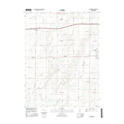
2016 Map of Jacksonburg
USGS Topo · Published 2016About this map
Hoover Mill and several historic burial grounds anchor this detailed study of the Wayne County landscape in the mid-2010s. The area is defined by its intricate drainage network, including Greens Fork, Nolands Fork, and many smaller tributaries like Snow Run Brook and Winter Run. These waterways historically shaped the placement of rural settlements and milling operations. Small community clusters such as Hiser, Pinhook, and Pennville are shown alongside the western edge of Centerville. Genealogists will find particular value in the clearly marked sites of the United Brethren Cem, West Grove Cem, and Franklin Cem, which preserve the names of early settler families and religious congregations in this agricultural region.
Find a feature on this map
97 named features on this map. Tap any name to fly to it.
Don’t see what you’re looking for? This feature index may not catch every label — zoom into the map to look around manually.
Map Details
Editions of this 2016 Jacksonburg Map
This is the sole edition of this map. No revisions or reprints were ever made.
Other maps of this area

1915 · New Paris
USGS Topo · 1:48,000

1915 · College Corner
USGS Topo · 1:48,000

1918 · College Corner
USGS Topo · 1:62,500

1918 · New Paris
USGS Topo · 1:62,500

1953 · Cincinnati
USGS Topo · 1:250,000

1956 · Brownsville
USGS Topo · 1:24,000

1956 · Connersville
USGS Topo · 1:24,000

1957 · Cincinnati
USGS Topo · 1:250,000

1960 · Liberty
USGS Topo · 1:24,000
1960 · Hagerstown
USGS Topo · 1:24,000