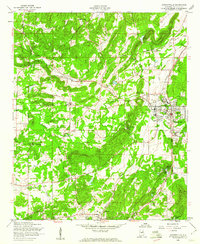
1956 Map of Jacksonville
USGS Topo · Published 1960About this map
Jacksonville serves as the focal point of this mid-century survey, centered around the State Teachers College and the local Vocational Sch. The landscape is defined by the corridors of the Southern Railroad and the Seaboard Air Line, which cross the valley floor alongside older routes like the Old Air Line Railroad. Rural life is anchored by numerous community landmarks such as Leydens Mill and Halls Chapel, while industrial and municipal development is represented by the Water Treatment Plant and a local Airstrip.
Find a feature on this map
41 named features on this map. Tap any name to fly to it.
Don’t see what you’re looking for? This feature index may not catch every label — zoom into the map to look around manually.
Map Details
Editions of this 1956 Jacksonville Map
3 editions found
Other maps of this area

1900 · Anniston
USGS Topo · 1:125,000

1947 · Anniston
USGS Topo · 1:24,000

1947 · Colvin Gap
USGS Topo · 1:24,000

1947 · Jacksonville
USGS Topo · 1:24,000

1947 · Glencoe
USGS Topo · 1:24,000

1947 · Wellington
USGS Topo · 1:24,000

1947 · Jacksonville
USGS Topo · 1:62,500

1947 · Eulaton
USGS Topo · 1:24,000

1950 · Anniston
USGS Topo · 1:62,500

1953 · Atlanta
USGS Topo · 1:250,000