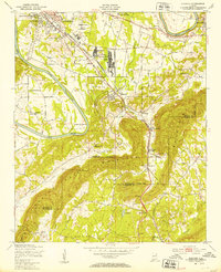
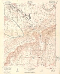
1947 Map of Glencoe
USGS Topo · Published 1953About this map
Industrial expansion and military operations define the landscape of eastern Alabama following World War II. The sprawling Gadsden Ordnance Plant and the Specialized Depot 889th AF sit just north of Glencoe, highlighting the region's significant role in defense and manufacturing. To the north, Camp Gadsden is situated near the Coosa River, which snakes through the territory and creates distinct peninsulas like Tidmore Bend and Horton Bend.
Find a feature on this map
46 named features on this map. Tap any name to fly to it.
Don’t see what you’re looking for? This feature index may not catch every label — zoom into the map to look around manually.
Map Details
Editions of this 1947 Glencoe Map
2 editions found
Other maps of this area

1885 · Gadsden
USGS Topo · 1:125,000

1888 · Gadsden
USGS Topo · 1:125,000

1889 · Springville
USGS Topo · 1:125,000

1892 · Springville
USGS Topo · 1:125,000

1892 · Gadsden
USGS Topo · 1:125,000

1893 · Fort Payne
USGS Topo · 1:125,000

1895 · Gadsden
USGS Topo · 1:125,000

1898 · Fort Payne
USGS Topo · 1:125,000

1900 · Fort Payne
USGS Topo · 1:125,000

1900 · Anniston
USGS Topo · 1:125,000