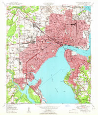
1950 Map of Jacksonville
USGS Topo · Published 1950About this map
The St Johns River serves as the central artery of this mid-century portrait, where the bustling city center meets a complex network of rail and industry. The downtown core is defined by the massive rail yards surrounding Union Station and the St Johns River Terminal RR, reflecting the city's role as a major southeastern transportation hub. Prominent educational and social landmarks like Edward Waters College, the County Hospital, and Robert E Lee High Sch are established within the urban grid, while the northern edge remains marked by the sprawling Evergreen Cemetery and the Municipal Golf Course.
Find a feature on this map
86 named features on this map. Tap any name to fly to it.
Don’t see what you’re looking for? This feature index may not catch every label — zoom into the map to look around manually.
Map Details
Editions of this 1950 Jacksonville Map
This is the sole edition of this map. No revisions or reprints were ever made.
Other maps of this area

1917 · Orange Park
USGS Topo · 1:62,500

1917 · Cambon
USGS Topo · 1:62,500

1918 · Middleburg
USGS Topo · 1:62,500

1918 · Cambon
USGS Topo · 1:62,500

1918 · Jacksonville
USGS Topo · 1:62,500

1918 · Orange Park
USGS Topo · 1:62,500

1941 · Middleburg
USGS Topo · 1:62,500

1948 · Jacksonville
USGS Topo · 1:250,000

1948 · Eastport
USGS Topo · 1:24,000

1949 · Jacksonville Heights
USGS Topo · 1:24,000
Featured Places
- Jacksonville, FL
- Lake Shore, Jacksonville
- Pearl Court, Jacksonville
- Saint Nicholas, Jacksonville
- Larsen, Jacksonville