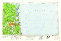
1960 Map of Jacksonville
USGS Topo · Published 1960About this map
The St Johns River and its complex network of inlets and tributaries anchor this coastal study, showing the region at a peak of mid-century military and maritime activity. The sprawl of Jacksonville is flanked by significant installations, including the Jacksonville Naval Air Station and Cecil Field Naval Air Station, while the Kings Bay Ammunition Terminal occupies the Georgia coastline to the north.
Find a feature on this map
176 named features on this map. Tap any name to fly to it.
Don’t see what you’re looking for? This feature index may not catch every label — zoom into the map to look around manually.
Map Details
Editions of this 1960 Jacksonville Map
This is the sole edition of this map. No revisions or reprints were ever made.
Other maps of this area

1917 · Orange Park
USGS Topo · 1:62,500

1917 · Nahunta
USGS Topo · 1:62,500

1917 · Cambon
USGS Topo · 1:62,500

1917 · Boulogne
USGS Topo · 1:62,500

1917 · Macclenny
USGS Topo · 1:62,500

1917 · Hilliard
USGS Topo · 1:62,500

1918 · St Marys
USGS Topo · 1:62,500

1918 · Cumberland Island
USGS Topo · 1:62,500

1918 · Folkston
USGS Topo · 1:62,500

1918 · Middleburg
USGS Topo · 1:62,500