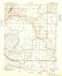
1943 Map of Jacksonville
USGS Topo · Published 1949About this map
Jacksonville sits at a transportation nexus in Pulaski County where the Missouri Pacific railroad intersects the Old Military Road. Surveyed in 1940, the landscape reveals a transition from the developing town site to the intricate hydrological systems of the Arkansas lowlands. The presence of the CCC Camp near the northern border reflects federal Depression-era activity just before the region's mid-century expansion. The map records a dense network of rural infrastructure, including many family and community landmarks such as Mc Craw Cem and Johnson Cem. To the south and east, the terrain is dominated by winding waterways like Meto Bayou and oxbow formations including Forty Point Lake and Lone Cypress Lake. Small educational and religious hubs like South Bend Sch, Concord Ch, and St Mathis Ch provide a detailed look at the social geography of this area during the early 1940s.
Find a feature on this map
42 named features on this map. Tap any name to fly to it.
Don’t see what you’re looking for? This feature index may not catch every label — zoom into the map to look around manually.
Map Details
Editions of this 1943 Jacksonville Map
2 editions found

Other maps of this area

1891 · Little Rock
USGS Topo · 1:125,000

1893 · Little Rock
USGS Topo · 1:125,000

1935 · Mc Almont
USGS Topo · 1:24,000

1935 · Sweet Home
USGS Topo · 1:24,000

1937 · England
USGS Topo · 1:48,000

1940 · Lonoke
USGS Topo · 1:62,500

1941 · Olmstead
USGS Topo · 1:31,680

1941 · Cabot
USGS Topo · 1:31,680

1942 · Scott
USGS Topo · 1:31,680

1943 · England
USGS Topo · 1:62,500