
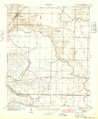
1943 Map of Jacksonville
USGS Topo · Published 1943About this map
Jacksonville sits at a geographic crossroads where the Missouri Pacific and Chicago Rock Island and Pacific railroads intersect with the historic Old Military Road. Surveyed just before the height of the Second World War, the landscape is defined by the winding course of Bayou Meto and the low-lying waters of Cypress Brake and Hill Lake. This 1940s topography captures the rural fabric of the Pulaski and Lonoke county line, where small rural schools like Pleasant Hill Sch and Martin Sch served dispersed farming communities.
Find a feature on this map
38 named features on this map. Tap any name to fly to it.
Don’t see what you’re looking for? This feature index may not catch every label — zoom into the map to look around manually.
Map Details
Editions of this 1943 Jacksonville Map
2 editions found
Other maps of this area

1891 · Little Rock
USGS Topo · 1:125,000

1893 · Little Rock
USGS Topo · 1:125,000

1935 · Mc Almont
USGS Topo · 1:24,000

1935 · Sweet Home
USGS Topo · 1:24,000

1937 · England
USGS Topo · 1:48,000

1940 · Lonoke
USGS Topo · 1:62,500

1941 · Olmstead
USGS Topo · 1:31,680

1941 · Cabot
USGS Topo · 1:31,680

1942 · Scott
USGS Topo · 1:31,680

1943 · England
USGS Topo · 1:62,500