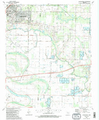
1987 Map of Jacksonville
USGS Topo · Published 1987About this map
Jacksonville anchors the northwest corner of this 1987 landscape, where the urban street grid quickly gives way to the extensive wetlands of the Holland Bottoms State Wildlife Management Area. The eastern half of the map is defined by a complex network of levees and waterways, including Bayou Two Prairie and Meto Bayou, which illustrate the intensive water management required for the region's agriculture and fish farms.
Find a feature on this map
44 named features on this map. Tap any name to fly to it.
Don’t see what you’re looking for? This feature index may not catch every label — zoom into the map to look around manually.
Map Details
Editions of this 1987 Jacksonville Map
2 editions found
Other maps of this area

1891 · Little Rock
USGS Topo · 1:125,000

1893 · Little Rock
USGS Topo · 1:125,000

1935 · Mc Almont
USGS Topo · 1:24,000

1935 · Sweet Home
USGS Topo · 1:24,000

1937 · England
USGS Topo · 1:48,000

1940 · Lonoke
USGS Topo · 1:62,500

1941 · Olmstead
USGS Topo · 1:31,680

1941 · Cabot
USGS Topo · 1:31,680

1942 · Scott
USGS Topo · 1:31,680

1943 · England
USGS Topo · 1:62,500