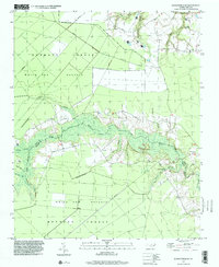
1997 Map of Jacksonville NE
USGS Topo · Published 2000About this map
The White Oak Pocosin dominates this Jones and Onslow County borderland, showcasing the characteristic wetland shrub-bog terrain of coastal North Carolina. Large tracts of the Hofmann Forest cover much of the western and southern reaches, where straight-cut access roads and private boundaries intersect the natural hydrology of the basin. The White Oak River meanders through the central landscape, fed by numerous tributaries including North Prong, South Prong, and Mundine Branch. Human settlement is concentrated along the river corridor and the northern survey limits, where the White Oak Ch and scattered Cem markers indicate established rural communities. Near the eastern edge, Gibson Bridge crosses the river, while the presence of the Bell Airport in the northeast corner and a Radio Tower suggests the integration of modern infrastructure into this heavily forested region.
Find a feature on this map
23 named features on this map. Tap any name to fly to it.
Don’t see what you’re looking for? This feature index may not catch every label — zoom into the map to look around manually.
Map Details
Editions of this 1997 Jacksonville NE Map
This is the sole edition of this map. No revisions or reprints were ever made.
Other maps of this area

1901 · New Bern
USGS Topo · 1:62,500

1903 · New Bern
USGS Topo · 1:62,500

1903 · Trent River
USGS Topo · 1:62,500

1904 · Trent River
USGS Topo · 1:62,500

1942 · Maysville
USGS Topo · 1:62,500

1943 · Jacksonville
USGS Topo · 1:62,500

1948 · Maysville
USGS Topo · 1:62,500

1950 · Pollocksville
USGS Topo · 1:24,000

1953 · Rocky Mount
USGS Topo · 1:250,000

1953 · Beaufort
USGS Topo · 1:250,000