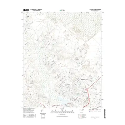
2016 Map of Jacksonville North
USGS Topo · Published 2016About this map
Jacksonville serves as the focal point for this survey of coastal North Carolina, where urban expansion meets the dense wetlands of the Atlantic coastal plain. The landscape is defined by the New River and its intricate network of tributaries, including Mill Creek and Half Moon Creek. The northern reaches are dominated by the extensive White Oak Pocosin, a unique shrub-bog ecosystem that transitions into the Bachelors Delight Swamp. This geography heavily influenced the layout of local infrastructure, with settlements like Gum Branch and Tar Landing situated on higher ground above the drainages. The map details the mid-2010s suburban growth of Jacksonville North, featuring the Coastal Carolina Community College campus and Onslow Memorial Park, providing a clear look at the region's contemporary development alongside its preserved natural marshlands.
Find a feature on this map
220 named features on this map. Tap any name to fly to it.
Don’t see what you’re looking for? This feature index may not catch every label — zoom into the map to look around manually.
Map Details
Editions of this 2016 Jacksonville North Map
This is the sole edition of this map. No revisions or reprints were ever made.
Other maps of this area

1943 · Jacksonville
USGS Topo · 1:62,500

1948 · Maple Hill
USGS Topo · 1:62,500

1948 · New River
USGS Topo · 1:62,500

1948 · Richlands
USGS Topo · 1:62,500

1952 · Camp Lejeune
USGS Topo · 1:24,000

1952 · Jacksonville South
USGS Topo · 1:24,000

1953 · Beaufort
USGS Topo · 1:250,000

1954 · Beaufort
USGS Topo · 1:250,000

1965 · Richlands
USGS Topo · 1:62,500

1972 · Beaufort
USGS Topo · 1:250,000
Featured Places
- Jacksonville, NC
- Half Moon, NC
- Gum Branch, NC
- Hickory Hills West Trailer Park, NC
- Warrens Trailer Park, NC