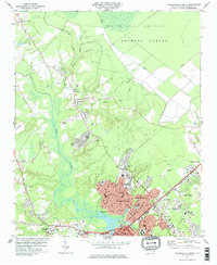
1978 Map of Jacksonville North
USGS Topo · Published 1978About this map
The New River meanders through Onslow County, shaping the growth of Jacksonville and its outlying neighborhoods in the late 1970s. The map reveals a community in transition, where new residential developments like Northwoods Park and Cardinal Village sit adjacent to established rural landmarks. Significant wetlands, including the White Oak Pocosin and Hofmann Forest, define the northern limits of the survey, while the southern reaches show the expanding footprint of the city near the Seaboard Coast Line.
Find a feature on this map
77 named features on this map. Tap any name to fly to it.
Don’t see what you’re looking for? This feature index may not catch every label — zoom into the map to look around manually.
Map Details
Editions of this 1978 Jacksonville North Map
This is the sole edition of this map. No revisions or reprints were ever made.
Other maps of this area

1943 · Jacksonville
USGS Topo · 1:62,500

1948 · Maple Hill
USGS Topo · 1:62,500

1948 · New River
USGS Topo · 1:62,500

1948 · Richlands
USGS Topo · 1:62,500

1952 · Camp Lejeune
USGS Topo · 1:24,000

1952 · Jacksonville South
USGS Topo · 1:24,000

1953 · Beaufort
USGS Topo · 1:250,000

1954 · Beaufort
USGS Topo · 1:250,000

1965 · Richlands
USGS Topo · 1:62,500

1972 · Beaufort
USGS Topo · 1:250,000