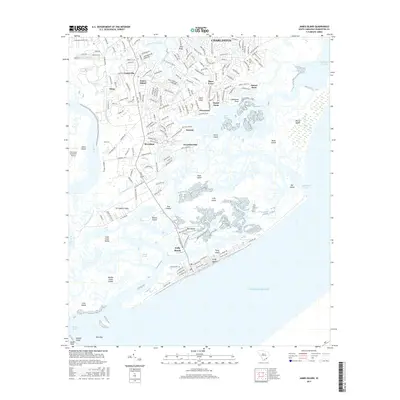
2017 Map of James Island
USGS Topo · Published 2017About this map
James Island and the surrounding coastal marshlands of South Carolina appear here in a period of established residential growth and preserved maritime heritage. The landscape is defined by the intricate network of tidal waterways such as James Island Creek, Simpson Cr, and the Stono River, which separate various landmasses including Sol Legare Island and Bowen Island. The settlement of Secessionville remains a focal point on the map, connected via Fort Lamar Rd to the broader island infrastructure. Further south, the oceanfront community of Folly Beach sits on Folly Island, separated from the mainland by Cutoff Reach. The map provides detailed local geography for researchers, showing everything from the Holy Cross Cem and Centerville to the Charleston Executive Airport on the western edge. This coastal topography reveals how the barrier islands and inlets like Lighthouse Inlet and Stono Inlet shape the region's relationship with the Atlantic Ocean.
Find a feature on this map
186 named features on this map. Tap any name to fly to it.
Don’t see what you’re looking for? This feature index may not catch every label — zoom into the map to look around manually.
Map Details
Editions of this 2017 James Island Map
This is the sole edition of this map. No revisions or reprints were ever made.
Other maps of this area

1918 · Kiawah Island
USGS Topo · 1:21,120

1919 · Johns Island
USGS Topo · 1:21,120

1919 · The Jetties
USGS Topo · 1:21,120

1919 · Wadmelaw Island
USGS Topo · 1:62,500

1919 · Charleston
USGS Topo · 1:21,120

1919 · James Island
USGS Topo · 1:21,120

1919 · Fort Moultrie
USGS Topo · 1:21,120

1919 · Legareville
USGS Topo · 1:21,120

1920 · Ravenels
USGS Topo · 1:62,500

1943 · Fort Moultrie
USGS Topo · 1:24,000