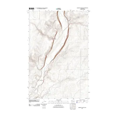
2011 Map of Jameson Lake SW
USGS Topo · Published 2011About this map
McCartney Creek carves a deep, winding path through the central plateau of Douglas County, defining the drainage patterns of this arid landscape. This 2011 survey reveals the isolated settlement of McCartney and the nearby Rimrock Meadows Airport, which serve as small focal points within an otherwise vast expanse of high-desert terrain. The map captures the specialized road network of the era, where routes like Jameson Lake Rd NE and Highland School Rd SE follow the section lines of the rectilinear grid. Significant topographical breaks occur at Sulphur Canyon and Armour Draw, while vital water sources are noted at Camel Spring and Coyote Spring, highlighting the essential landmarks for livestock and land management in this portion of the Washington interior.
Find a feature on this map
18 named features on this map. Tap any name to fly to it.
Don’t see what you’re looking for? This feature index may not catch every label — zoom into the map to look around manually.
Map Details
Editions of this 2011 Jameson Lake SW Map
This is the sole edition of this map. No revisions or reprints were ever made.
Other maps of this area

1953 · Ritzville
USGS Topo · 1:250,000

1956 · Ephrata
USGS Topo · 1:62,500

1959 · Ritzville
USGS Topo · 1:250,000

1965 · Ritzville
USGS Topo · 1:250,000

1965 · Jameson Lake SW
USGS Topo · 1:24,000

1965 · Jameson Lake SE
USGS Topo · 1:24,000

1965 · Jameson Lake West
USGS Topo · 1:24,000

1965 · Jameson Lake East
USGS Topo · 1:24,000
1966 · Rattlesnake Springs
USGS Topo · 1:24,000

1968 · Withrow
USGS Topo · 1:24,000