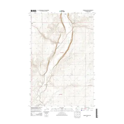
2014 Map of Jameson Lake SW
USGS Topo · Published 2014About this map
McCartney sits within a landscape defined by the dramatic descent of the Moses Coulee, where the terrain drops sharply from the surrounding plateaus. This 2014 survey details the intricate drainage systems that feed into the coulee, including Armour Draw and Sulphur Canyon. The presence of Sulphur Spring, Garnet Spring, and Coyote Spring highlights the vital water sources in this arid region, which historically dictated the placement of homesteads and grazing routes. A network of rural roads like Moses Coulee Rd SE and Highland School Rd SE follows the natural contours of the land, connecting the valley floor to the high ground. The map provides a clear picture of the Public Land Survey System divisions, from t23n r25e to t25n r25e, showing how the grid of the American West was laid over the winding path of McCartney Cr.
Find a feature on this map
16 named features on this map. Tap any name to fly to it.
Don’t see what you’re looking for? This feature index may not catch every label — zoom into the map to look around manually.
Map Details
Editions of this 2014 Jameson Lake SW Map
This is the sole edition of this map. No revisions or reprints were ever made.
Other maps of this area

1953 · Ritzville
USGS Topo · 1:250,000

1956 · Ephrata
USGS Topo · 1:62,500

1959 · Ritzville
USGS Topo · 1:250,000

1965 · Ritzville
USGS Topo · 1:250,000

1965 · Jameson Lake SW
USGS Topo · 1:24,000

1965 · Jameson Lake SE
USGS Topo · 1:24,000

1965 · Jameson Lake West
USGS Topo · 1:24,000

1965 · Jameson Lake East
USGS Topo · 1:24,000
1966 · Rattlesnake Springs
USGS Topo · 1:24,000

1968 · Withrow
USGS Topo · 1:24,000