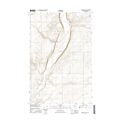
2017 Map of Jameson Lake SW
USGS Topo · Published 2017About this map
Sulphur Canyon and Armour Draw define the elevation changes of this Douglas County landscape, where the high plateaus drop sharply into the valley floors. Water sources are critical markers in this arid environment, with McCartney Cr flowing through the coulees alongside several named springs, including Sulphur Spring, Camel Spring, and Coyote Spring. The transportation network is built upon a strict section-line grid, exemplified by E Baseline Rd and a series of numbered rural routes like Rd 2 SE. Following the natural contours of the land, Moses Coulee Rd and S Jameson Lake Rd provide the primary north-south passage through the drainage basins. This 2017 survey details the intersection of modern road infrastructure with the timeless geological features of the Washington shrub-steppe.
Find a feature on this map
29 named features on this map. Tap any name to fly to it.
Don’t see what you’re looking for? This feature index may not catch every label — zoom into the map to look around manually.
Map Details
Editions of this 2017 Jameson Lake SW Map
This is the sole edition of this map. No revisions or reprints were ever made.
Other maps of this area

1953 · Ritzville
USGS Topo · 1:250,000

1956 · Ephrata
USGS Topo · 1:62,500

1959 · Ritzville
USGS Topo · 1:250,000

1965 · Ritzville
USGS Topo · 1:250,000

1965 · Jameson Lake SW
USGS Topo · 1:24,000

1965 · Jameson Lake SE
USGS Topo · 1:24,000

1965 · Jameson Lake West
USGS Topo · 1:24,000

1965 · Jameson Lake East
USGS Topo · 1:24,000
1966 · Rattlesnake Springs
USGS Topo · 1:24,000

1968 · Withrow
USGS Topo · 1:24,000