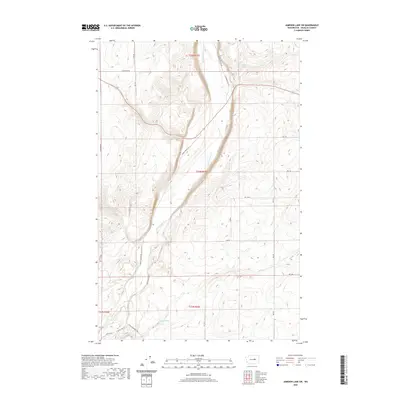
2020 Map of Jameson Lake SW
USGS Topo · Published 2020About this map
Moses Coulee dominates this Douglas County landscape, revealing the dramatic geological forms of the Columbia Plateau. This 2020 USGS survey records a sparsely populated region characterized by deep canyon walls and dry drainage systems, where local water sources like Sulphur Spring and Coyote Spring historically anchored life in an arid environment. The map details the winding course of McCartney Cr as it flows through the floor of the coulee, paralleled by a network of rural routes such as S Jameson Lake Rd. While the northern reaches are defined by larger sections and section lines like E Baseline Rd, the southwestern corner shows more recent residential development near the junction of Coulee Meadows Rd, including suburban-style naming conventions like White Oaks Dr and Ashwood Pl.
Find a feature on this map
28 named features on this map. Tap any name to fly to it.
Don’t see what you’re looking for? This feature index may not catch every label — zoom into the map to look around manually.
Map Details
Editions of this 2020 Jameson Lake SW Map
This is the sole edition of this map. No revisions or reprints were ever made.
Other maps of this area

1953 · Ritzville
USGS Topo · 1:250,000

1956 · Ephrata
USGS Topo · 1:62,500

1959 · Ritzville
USGS Topo · 1:250,000

1965 · Ritzville
USGS Topo · 1:250,000

1965 · Jameson Lake SW
USGS Topo · 1:24,000

1965 · Jameson Lake SE
USGS Topo · 1:24,000

1965 · Jameson Lake West
USGS Topo · 1:24,000

1965 · Jameson Lake East
USGS Topo · 1:24,000
1966 · Rattlesnake Springs
USGS Topo · 1:24,000

1968 · Withrow
USGS Topo · 1:24,000