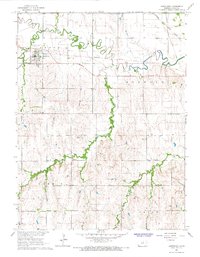
1966 Map of Jamestown
USGS Topo · Published 1967About this map
Jamestown serves as the focal point of this North Central Kansas landscape, situated where the Missouri Pacific railroad intersects the meandering path of Buffalo Creek. The survey captures a mid-1960s agricultural environment defined by the township boundaries of Grant, Buffalo, Summit, and Arion. Evidence of local industry and infrastructure is visible through several Quarry sites and a Gaging Sta located along the creek banks north of town. For genealogists and local historians, the map identifies key community landmarks such as the Community Hall and multiple burial grounds, including Fairview Cem and West Summit Cem. The dual presence of the Atchison Topeka and Santa Fe and the Missouri Pacific lines illustrates the importance of rail transit to the regional economy during this period.
Find a feature on this map
19 named features on this map. Tap any name to fly to it.
Don’t see what you’re looking for? This feature index may not catch every label — zoom into the map to look around manually.
Map Details
Editions of this 1966 Jamestown Map
This is the sole edition of this map. No revisions or reprints were ever made.
Other maps of this area

1892 · Concordia
USGS Topo · 1:125,000

1892 · Minneapolis
USGS Topo · 1:125,000

1953 · Glasco NE
USGS Topo · 1:24,000

1953 · Simpson
USGS Topo · 1:24,000

1955 · Manhattan
USGS Topo · 1:250,000

1956 · Manhattan
USGS Topo · 1:250,000

1957 · Manhattan
USGS Topo · 1:250,000
1965 · Aurora NW
USGS Topo · 1:24,000

1965 · Concordia NW
USGS Topo · 1:24,000
1965 · Concordia
USGS Topo · 1:24,000